by copenasia | Jun 20, 2025
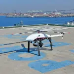
Aerial Surveying UAV Photogrammetry The Velos V3 equipped with a high-resolution RGB camera system, such as Sony ILX-LR1, provides a highly capable solution for UAV photogrammetry. Its 90-minute flight time and high cruise speed enable not only the consistent capture...
by copenasia | Jun 20, 2025
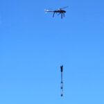
Aerial Surveying Magnetic Surveying Velos V3 can deliver the most reliable and efficient UAV magnetometer surveys. The Velos V3 paired with a magnetometer sensor, such as the V2MAG system from UMAG Solutions, constitutes a high-level combo, which offers a reliable...
by copenasia | Jun 20, 2025
Aerial Surveying UAV Crop Monitoring Velos V3 is a high-end UAV for crop monitoring and agriculture surveying. Like in LiDAR surveying, Velos Rotors aircraft equipped with multispectral or hyperspectral cameras capture vast amounts of data in a single flight,...
by copenasia | Jun 13, 2025
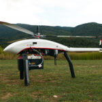
Aerial Surveying LiDAR Surveying Velos V3 is a world class trusted UAV for LiDAR surveying & mapping. The Velos V3 supports LiDAR sensors up to 10kg, including models like the Riegl VQ-840. With flight speeds of up to 20 m/s and a quick-disconnect payload base,...